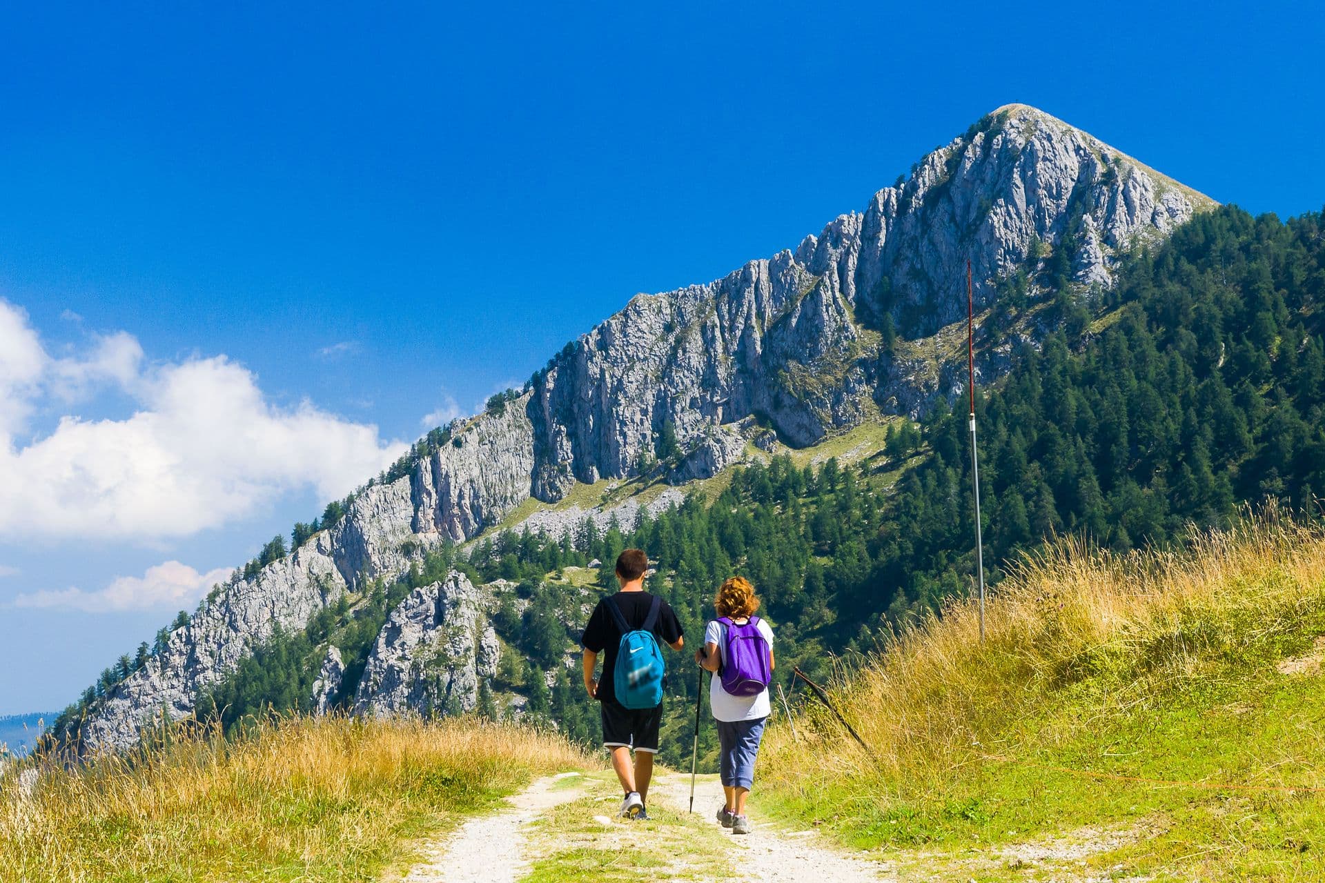
Alta Via dei Monti Liguri
Come percorrerlo
44
Distanza
440
Durata
6-8
Thousands of kilometers of paths and mule tracks, which can be traveled all year round, linking the ends of the Ligurian Riviera from Ventimiglia to Ceparana, from the Province of Imperia to the Province of La Spezia. A journey between the coast and the hinterland, between the Alps and the Apennines, between the sea and the sky, along grassy meadows that rarely drop below a thousand meters of altitude, in a harsh and sweet environment at the same time where driveways often never reach .
The Alta Via dei Monti Liguri (which Cammini d'Europa has been following for some time) is a perfect itinerary for everyone: for those who want to discover the most remote corners of the Ligurian hinterland, for those in search of adventure, for those who want spend a quiet weekend in contact with nature or for the family on a Sunday trip.
Following the trail sign – the white/red flag with the word “AV” in the center – it is not difficult to identify the route, drawing a large green road where sunny ridges alternate with shady woods and where orographic mists sometimes create surreal shapes and atmospheres: a single route, from which it is possible to admire Corsica, Monviso and the Monte Rosa Massif at the same time.
The historical and cultural heritage is also noteworthy along the entire route, just think of the mighty line of fortifications in the west or the numerous and very ancient rural settlements that border the ridge at various points along the route: Realdo (IM), Canate (GE) and Zignago (SP), just to name a few.
Each stage of the Alta Via can be an opportunity to organize a visit to a village, a castle, a museum, but also to participate in one of the traditional festivals and fairs that enliven the Ligurian territory in all seasons of the year .
And then… there is nature. Together with the sites of the Natura 2000 network, the system of parks and the regional ecological network, the Alta Via constitutes a "connection corridor" par excellence, particularly valuable for macrofauna.
The route and stages
The path is divided into 8 homogeneous territorial areas:
Val Nervia
From Ventimiglia to the forest of Testa d'Alpe via the fossil cliffs of Roverino, you cross terraced olive trees and Rossese vineyards and then further up, towards the high altitude, thyme and lavender bushes with their inebriating aromas alternate with rare flora alpine type. A true treasure trove of biodiversity, a naturalistic sanctuary where holm oaks, maples and beeches mix with larch, spruce and fir woods and where eagles, chamois and wolves live almost in contact with typically Mediterranean species such as the Ocellated Lizard. One of the most suggestive passages is the Sentiero degli Alpini, a path dug into the overhanging rock that extends along the eastern slopes of the Pietravecchia (2,038 m) and Toraggio (1,972 m) mountains. Due to the rocky substrate, made up of dolomitic limestone, it recalls the routes of the great war in the eastern Alps but with characteristics that make it unique: the microclimate and the breathtaking views of the Ligurian Sea. The trail was built for military purposes in the second half of the 1930s in order to prevent the fire of the French lines. The daring passages, the dry stone walls and the numerous galleries make it a suitable route for expert hikers.
Ligurian Alps
The route crosses dense coniferous woods and vast summit meadows where, in late spring, large expanses of rhododendron bloom, giving the pastures the typical appearance of northern European heaths. Entering the heart of the Ligurian Alps Park (established with Regional Law 34/07), you reach the top of Monte Saccarello (2,201 m) from which you can enjoy a magnificent panorama that sweeps over the sea and the mountains. On the eastern foresummit, at an altitude of 2,166 m, stands the imposing cast iron statue of the Redeemer. At the foot of the massif, as evidence of the historical and cultural complexity of this corner of Liguria, lie the ancient Brigaschi villages of Realdo and Verdeggia. Thanks also to the contiguity with Val Tanarello, the pristine environment and the size of the area have favored the conservation of the alpine fauna (hare, chamois, marten, marmot) and a rich birdlife. Near Colle di Nava (934 m), we meet the first Savoy fortifications built, in strategic points, to defend the Kingdom of Sardinia.
pomegranate
Monte Galero (1704 m), Rocca Barbena (1140 m) and Monte Carmo di Loano (1389 m), are the reliefs that most characterize this stretch of the route. Spectacular sculptures of rocky conglomerate called "Stone Giants ?, stand out in the sky near the top of Galero, while from the top you can admire fascinating perspectives on the underlying Val Tanaro and Val Pennavaira. Further east, other monolithic sculptures contribute to shaping the rugged and evocative Rocca Barbena. Environments with very different microclimatic characteristics give this district a considerable botanical interest, with the presence of typically Nordic species such as blueberry, dwarf juniper and rhododendron. After Monte Carmo, you enter the Melogno beech forest which has been an invaluable asset for the local populations for centuries. In the forest, remarkable for its vastness and value, in addition to the beech, there are: birch, silver fir, Scots pine, ash and mountain maple.
Beigua
Crossing one of the areas with the highest forest density in Italy, there is no shortage of reasons of great environmental and landscape interest. Long stretches of shaded road run inside thick woods, interspersed with passes dotted with mighty 19th-century fortifications and other military works. Near Meugge, the itinerary runs alongside the Adelasia Nature Reserve for several kilometers: an area that embraces the tributary slopes of the Rio Ferranietta characterized by the rocky outcrops of the Rocca dell'Adelasia and the Bric dell'Amore. At Colle del Giovo, you then enter the Beigua Park. The Alta Via crosses the plateaus of the massif here, running at over 1000 m above sea level just a few kilometers from the coastline. The panorama is breathtaking, the climate unpredictable and the vegetation, adapted to the particular environmental and climatic conditions as well as to the magmatic soils, is unique. In the wooded areas, it happens to see families of fallow deer crossing the path, while on the stony plateaus and in the adjacent valleys, various specimens of diurnal birds of prey can be sighted with relative ease.
Praglia
Access to this stretch, always characterized by its panoramic views, is facilitated by the presence of the railway lines in Masone (connection with Cappelletta di Masone) and, further east, in Crocetta d'Orero, where the picturesque "trenino di Casella" passes ". From Bric del Dente you pass by the imposing fortification of Bric Geremia to reach, after a few kilometres, near the Shrine of the Martyrs of Turchino which recalls the massacre (1944) of partisans and political prisoners. The "path of memory" continues towards Piani di Praglia where tombstones and memorial stones scattered everywhere testify to the partisan events linked to these grim mountains. The particularity of the soils means that these reliefs are almost completely devoid of vegetation, a feature that makes the summit plateaus even more suggestive. Punta Martìn, a very popular destination for hikers and mountaineers, is of considerable morphological interest due to the spectacular erosion phenomena. Nearby, at the Gorzente Lakes and at the Bocchetta Pass, snow caves in a good state of conservation can be admired.
Scoffera
An ancient funicular (1901) and a narrow-gauge railway (1929) lead to Righi and Casella, allowing convenient, as well as ecological, access to the ancient salt road which connected Genoa to the Po Valley via Crocetta d'Orero. Beyond Colle di Creto, the Val Noci offers views of the lake of the same name and the peasant villages and then, variants to the Alpesisa and Candelozzo mountains and the ancient nuclei of Canate and Scandolaro. Some important paths branch off from Monte Lavagnola; one of these leads to Monte Antola (included in the territory of the Antola Regional Natural Park), a destination of significant historical and botanical interest. On the way to the Passo della Forcella, two places of great beauty meet: a short distance from the Passo della Scoglina you can reach Monte Caucaso and the sources of the Aveto stream, further east, Monte Ramaceto, immediately stands out thanks to the characteristic amphitheater shape.
Zatta
From Passo della Forcella, you enter the heart of the Aveto Regional Natural Park, an area of great importance in terms of nature, landscape and for the persistence of typical traditions and activities. Historical evidence can be found almost everywhere; at Passo del Bozale, for example, the medieval route passes from V. Sturla to V. d'Aveto, with long stretches of well-preserved pavement. After the Cappelletta delle Lame you can access, with a short detour, the system of lakes of glacial origin located on the western slopes of Monte Aiona. From its summit, renowned among Genoese mountaineers for its frozen gullies, you can admire a vast glacial cirque located between Monte Penna and Passo dell'Incisa. After passing the stupendous beech forest of Monte Zatta, the long and easy route leads to Passo di Cento Croci, an ancient pass between the Republic of Genoa and the Duchy of Parma.
Val di Vara
The entire route is characterized by the alternation of mixed deciduous woods, large grasslands intended for grazing (at the highest altitudes) and reforestation with conifers. Monte Gottero (1,640 m), the highest peak in eastern Liguria, is a wildlife oasis and an interesting area for the alpine flora, present with some uncommon species and numerous endemisms, and for the high panoramic views. Not far away, Foce dei Tre Confini reminds us that this stretch of watershed was, for a long time, the border line between the Republic of Genoa, the Duchy of Parma and the Grand Duchy of Tuscany. After passing the Calzavitello and Rastello passes, you pass along a formidable observation point from which you can see the Apuan Alps and the Gulf of Poets, next to Monte Cornoviglio (1160 m). A short distance away, after passing the characteristic birch forest in Vallecchia, you can visit the beautiful historic center of Bolano. From Ceparana, connections with the Alta Via del Golfo, Montemarcello and Bocca di Magra are being built by the Montemarcello-Magra Park (which can also be reached thanks to the park's river boat service).
| stage | Path | KM | Maximum altitude above sea level |
|---|---|---|---|
| 1 | Ventimiglia (IM) – La Colla | 10 | 510 – Monte Baraccone |
| 2 | The Glue – Colla Sgora | 9 | 1063 – Colla Sgora |
| 3 | Colla Sgora – Colla Scarassan | 12,2 | 1587 – Testa d’Alpe |
| 4 | Colla Scarassan – Sella d’Agnaira | 13 | 1909 – Passo della Valletta |
| 5 | Sella d’Agnaira – Sella della Valletta | 15 | 2201 – Monte Saccarello |
| 6 | Sella della Valletta – Colle San Bernardo di Mendatica (IM) | 10 | 2085 – Monte Cimonasso |
| 7 | Colle San Bernardo di Mendatica – Colle di Nava (IM) | 10,5 | 1356 – Poggio dei Preti |
| 8 | Colle di Nava – Passo di Pralè | 6 | 1258 – Passo di Pralè |
| 9 | Passo di Pralè – Colle San Bartolomeo d’Ormea (CN) | 8,8 | 1739 – Monte Armetta |
| 10 | Colle San Bartolomeo d’Ormea – Colle San Bernardo di Garessio (CN) | 13,5 | 1708 – Monte Galero |
| 11 | Colla San Bernardo di Garessio – Colle Scravaion (SV) | 9,4 | 1084 – Bric Schenasso |
| 12 | Colle Scravaion – Giogo di Toirano (SV) | 5,7 | 971 – Sella Nord Monte Sebanco |
| 13 | Giogo di Toirano – Giogo di Giustenice (SV) | 7 | 1389 – Monte Carmo |
| 14 | Giogo di Giustenice – Colle del Melogno (SV) | 9 | 1335 – Bric Agnellino |
| 15 | Colle del Melogno – Colla di San Giacomo (SV) | 15 | 1028 – Colle del Melogno |
| 16 | Colle San Giacomo – Colle di Cadibona (SV) | 13 | 821 – Monte Baraccone |
| 17 | Colle di Cadibona – Le Meugge (SV) | 11,4 | 720 – Le Meugge |
| 18 | Le Meugge – Colle del Giovo (SV) | 11,7 | 883 – Bric Sportiole |
| 19 | Colle del Giovo – Prà Riondo (SV) | 13 | 1287 – Monte Beigua |
| 20 | Pra Riondo – Passo del Faiallo (SV) | 8,8 | 1145 – Cima Frattin |
| 21 | Passo del Faiallo – Passo del Turchino (GE) | 8,8 | 1061 – Passo del Faiallo |
| 22 | Passo del Turchino – Colla di Praglia (GE) | 11,5 | 960 – Colle Sud Monte Foscallo |
| 23 | Colla di Praglia – Passo della Bocchetta (AL-GE) | 13 | 1065 – Sella Nord Monte Taccone |
| 24 | Passo della Bocchetta – Passo dei Giovi (GE) | 6 | 785 – Pian di Reste |
| 25 | Passo dei Giovi – Crocetta d’Orero (GE) | 7,4 | 680 – Sella Sud Monte Vittoria |
| 26 | Crocetta d’Orero – Colle di Creto (GE) | 7,8 | 795 – Sella Sud Monte Carossino |
| 27 | Colle di Creto – Passo dello Scoffera (GE) | 14 | 978 – Passo del Fuoco |
| 28 | Passo della Scoffera – Sella della Giassina | 8,2 | 1080 – Valico Monte Lavagnola |
| 29 | Sella della Giassina – Barbagelata (GE) | 6,5 | 1120 – Barbagelata |
| 30 | Barbagelata – Passo di Ventarola | 9,2 | 1120 – Barbagelata |
| 31 | Passo di Ventarola – Passo della Forcella (GE) | 9,7 | 1345 – Monte Ramaceto |
| 32 | Passo della Forcella – Passo delle Lame | 7,2 | 1300 – Passo delle Lame |
| 33 | Passo delle Lame – Passo della Spingarda (GE-PR) | 7,6 | 1701 – Monte Aiona |
| 34 | Passo della Spingarda – Passo del Bocco (GE-PR) | 13,8 | 1623 – Sella del Monte Nero |
| 35 | Passo del Bocco – Colla Craiolo | 9 | 1404 – Monte Zatta |
| 36 | Colla Craiolo – Passo di Centocroci (SP-PR) | 16 | 1177 – Monte Ventarola |
| 37 | Passo di Centocroci – Passo della Cappelletta | 5 | 1102 – Passo Scassella |
| 38 | Passo della Cappelletta – Passo dei Due Santi | 17 | 1640 – Monte Gottero |
| 39 | Passo dei Due Santi – Passo Calzavitello | 11,6 | 1583 – Monte Tecchione |
| 40 | Calzavitello Pass – Rastello Pass | 5,6 | 1161 – Monte Antessio |
| 41 | Rastello Pass – Casoni Pass | 10,2 | 1093 – Monte Fiorito |
| 42 | Passo dei Casoni – Passo Alpicella | 8,6 | 1062 – La Conchetta |
| 43 | Alpicella Pass – Solini Pass | 5,4 | 720 – Monte Belvedere |
| 44 | Valico del Solini – Ceparana (SP) | 11,3 | 575 – Valico del Solini |
Share this article: